DACF Home → Bureaus & Programs → Maine Geological Survey → Explore Maine Geology → Water Resources
Maine's Water Resources
Overview
- Precipitation: Water that falls to the Earth’s surface from the atmosphere as rain, sleet, or snow. Average annual precipitation is 46 inches, or 28 trillion gallons.
- Maine Cooperative Snow Survey | Maine Geological Survey
- NOAA Meteorological Station Data: NOAA NCEI U.S. Climate Normals Quick Access
- Evapotranspiration: About 35% of precipitation, or 9.9 trillion gallons annually, is transferred from the land to the atmosphere by evaporation and plant transpiration.
- Run-off: About 50% of precipitation, 14.1 trillion gallons annually, runs-off the landscape to surface waters.
- Infiltration to groundwater: About 15% of precipitation, 4.2 trillion gallons annually, infiltrates the ground and recharges groundwater aquifers.
- Drought: Prolonged period of abnormally low rainfall, corresponding with dry soil, low groundwater levels, and low stream/lake levels.
- Drought monitor Maine | U.S. Drought Monitor
- Drought Task Force | Maine Emergency Management Agency
- Dry Well Survey | Maine Drought Task Force
- Our virtual tour is a series of photos which portray issues related to water supplies, wells, and environmental issues.
- Frequently Asked Questions
- USGS: Learn About Water
- Maine Water Resources Planning Committee
Surface Water
Surface water refers to all water that is on the Earth’s surface, including rivers/streams, lakes, and wetlands.
- USGS Stream Data for Maine
- Maine Dept of Inland Fisheries and Wildlife Lake Survey Maps
- Maine Bureau of Parks and Lands Ice Out Dates
- Lake Stewards of Maine
- KnowledgeBase - Data sets for the Gulf of Maine Watershed
- USFWS Wetlands Mapper
- MGS publications
- Measurement of Stream Discharge Using Weirs and Flumes by Daniel B. Locke
- Engineered Solutions to Stream Bank Erosion: A Case Study by Daniel B. Locke
- Sandy River Bank Erosion, Avon, Maine - 2nd Update by Daniel B. Locke
- Natural Processes Affecting Stream Bank Erosion: An Update to "Engine by Daniel B. Locke
- Ice Jam on the Kennebec River on Wednesday, February 17, 2016 by Ryan P. Gordon and Amber T.H. Whittaker
- Why is Sebago Lake so deep? by Robert A. Johnston
- Summary of Sebago Lake Shoreline Change Studies, 1990-1997 by Robert A. Johnston and Martha M. Mixon
- Songo Beach, Sebago Lake State Park by Robert A. Johnston
- Bottom Sediments of Sebago Lake by Robert A. Johnston
- Shoreline classification of Sebago Lake by Robert A. Johnston
- The Sunkhaze Peatland Complex by Daniel B. Locke
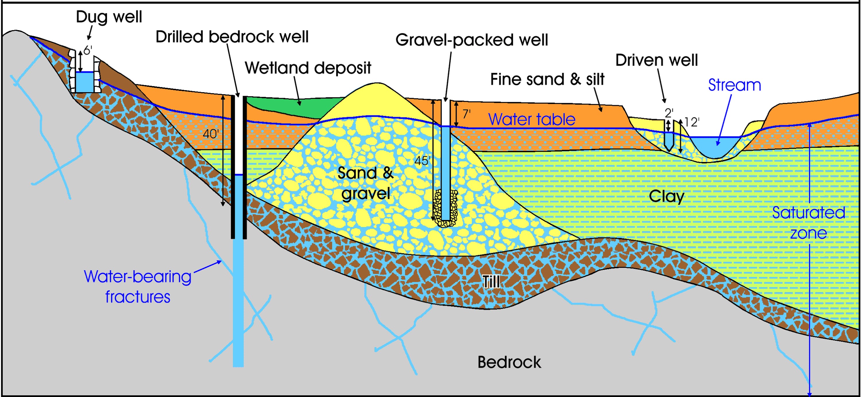
Groundwater and Wells
Introduction to Maine Groundwater and Aquifers
- What is ground water?
- Ground Water Handbook for the State of Maine
- Maine Sand and gravel aquifers
- Maine Springs
- Data
Wells
- Water Well Database - Downloadable database of located water wells.
- Groundwater Technical Assistance Bulletin (pdf)
- Anatomy of a drilled bedrock well
- Maine's Dug Wells
- Water Systems Council wellcare Information Sheets - fact sheets about wells, well components, water testing, and contamination
- Locating Your Well and Septic System - A Homeowner's Guide by Daniel B. Locke
Water Quality
- Maine Center for Disease Control & Prevention - Drinking Water Safety provides information regarding Public Water Systems, Private wells, Drinking Water Contaminants, Water testing, and more.
- Maine Department of Environmental Protection - Groundwater provides information about regulations, reporting, and monitoring related to protecting water resources in Maine.
- Some common water quality issues in Maine include:
- Alkalinity: An Important Parameter in Assessing Water Chemistry
- Corrosive Water: Facts, Common Questions, and Resources
- Radon: Maine Department of Health and Human Services - Radon; USGS The Geology of Radon; U.S. EPA Radon-Specific Publications and Resources
- Arsenic: Arsenic in Groundwater; Arsenic in Drinking Water and Treatment Technologies; Have you tested your well water for arsenic? (pdf); U.S. EPA Arsenic in Drinking Water
- Uranium: Uranium in my well water: Now what do I do?
Regulations
- Review of Ground-Water Withdrawal Regulations
- Water Laws, Maine Department of Environmental Protection
Other MGS Publications
- "How much snow is out there anyway?" by Henry N. Berry IV and Marc C. Loiselle
- "Water, water everywhere...." by Marc C. Loiselle
- Sand and gravel aquifer maps - A work in progress
- Seismic refraction profiling: An important tool used in mapping sand and gravel aquifers
- Hydrogeology of the Bingham Water District Well
- Hydrogeology of the Governor Hill Fish Hatchery, Augusta
- Maine's Highest Yielding Well
- Groundwater, Wells and the Summer of 1999
- The Freeport Basin Study: A Cooperative Investigation of Water Use
Water Use
MGS Studies
MGS has collected and estimated water use information in coordination with other State agencies, USGS, and other stakeholders. Water use data reports have been delivered to the State legislature as well as the USGS. The following reports have been published from this work:
- Annual Report of the Water Withdrawal Reporting Program: 2006, 2007, 2008
- Sources of water-use information in Maine by Dorothy H. Tepper and E Melanie Lanctot
- Survey of Agricultural Water Users in Maine: Results for Calendar Year by Ryan P. Gordon et al.
- Improving Agricultural Water Use Data in Maine, 2016-2018 by Ryan P. Gordon et al.
- Improvements to Domestic Water Use Data Collection Methods and Population Estimates for Maine by Ryan P. Gordon et al.
- Improvements to Industrial Water Use Data Collection for Maine, 2019-2022 by Ryan P. Gordon et al.
USGS Studies
USGS has collected and estimated water use information in cooperation with State, Federal, and local agencies. Compilation “snapshots” were developed for Maine every 5 years 1985-2015.
The USGS has been developing national water-use model. Utilizing machine-learning and modeling, water use can be estimated more consistently and with greater resolution. So far, the USGS has released data products:
- Public supply water use reanalysis for the 2000-2020 period by HUC12, month, and year for the conterminous United States (ver. 2.0, August 2024)
- Thermoelectric-power condenser duty estimates by month and cooling type for use to calculate water use by power plant for the 2008-2020 reanalysis period for the conterminous United States
- Irrigation water use reanalysis for the 2000-20 period by HUC12, month, and year for the conterminous United States (ver. 2.0, September 2024)
The data for Maine can be accessed via the National Water Availability Assessment Data Companion and is summarized at New England Water Use.
Last updated on April 27, 2026